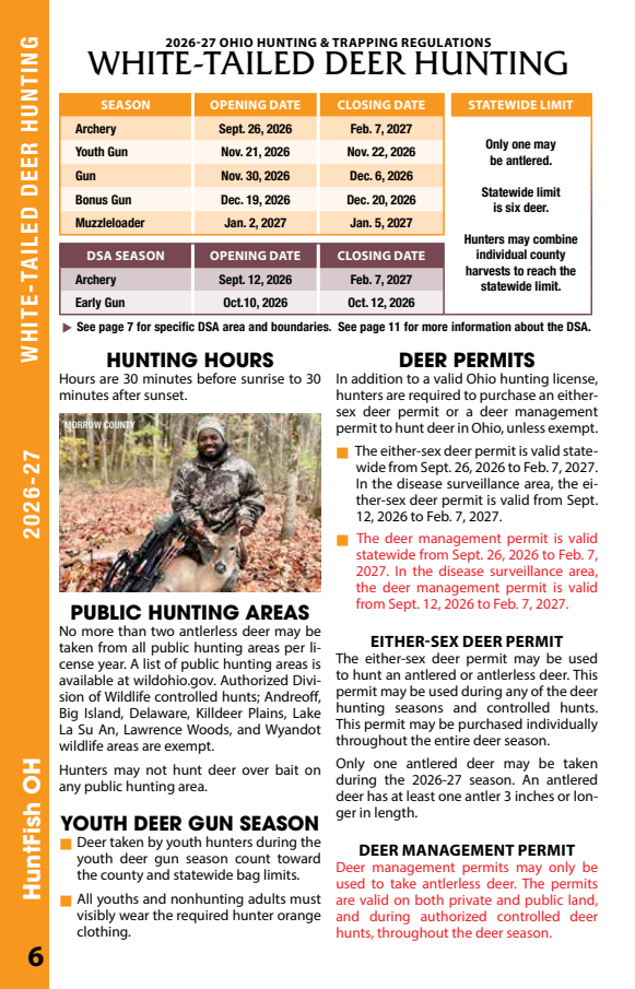
Archery
Sept. 26, 2026 – Feb. 7, 2027
opens in 3 days derived as of Sep 23
2026-09-26 → 2027-02-07 derived
| closes | Feb. 7, 2027 |
|---|---|
| opens | Sept. 26, 2026 |
show me the page
source
Archery Sept. 26, 2026 Feb. 7, 2027
This record does not carry 2 regulations the state has. The declarations below are the record's own words.
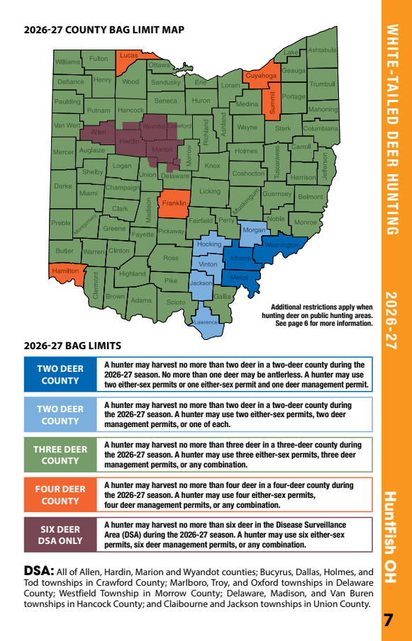
kind: map — description: PAGE 7. The "2026-27 COUNTY BAG LIMIT MAP" - a map of all 88 Ohio counties, measured at 26.8% of the page, together with the five colour swatches of the 2026-27 BAG LIMITS panel that key it. **THE FIVE COUNTY BAG LIMIT ROWS PUBLISHED FROM THIS PAGE SAY WHAT EACH CLASS OF COUNTY ALLOWS AND THIS COMPILATION DOES NOT SAY WHICH CLASS ANY COUNTY IS IN.** That assignment exists in the map's colouring and nowhere else on the page: the county names are drawn as vector outlines, not text, so neither pypdf nor pdfplumber sees one of them - both read this page as the same 36 lines and 1,594 characters, in which no county name from the map appears, and the divergence check is therefore blind to the omission too. Worse than the Kentucky and Florida cases in one respect: TWO DEER COUNTY is printed twice with DIFFERENT rules - the dark blue class adds "No more than one deer may be antlerless" and the light blue class does not - so even a hunter who knew their county was a two-deer county could not tell from these rows which of the two applies.
kind: cross-references — description: PAGE 11, named by page 6 and not read here. The pointer beneath the season tables reads "See page 11 for more information about the DSA.", published above as a hunt_note. Page 11 is headed "DISEASE SURVEILLANCE AREA (DSA)" and carries deer regulation these rows do not: a MANDATORY SAMPLING requirement for deer harvested inside the DSA on named dates, and DEER CARCASS REGULATIONS restricting which parts may be moved out of a disease surveillance area. A hunter who may lawfully take a deer under the DSA rows published here is subject to requirements this compilation does not carry.
in season now DSA Archery runs through 2027-02-07 derived as of Sep 23
Do not take our word for it. The document every row on this page was read out of is one tap away, and checking us against it is exactly what the citation, the sha256 and the source lines under each row are for.
Open the source document → https://dam.assets.ohio.gov/image/upload/ohiodnr.gov/documents/wildlife/laws-regs-licenses/Ohio%20Hunting%20and%20Trapping%20Regulations%20ENGLISH.pdfIf that document says something this page does not, the document is the regulation and this page is wrong. The copy we read is the one whose sha256 is above; if the publisher has replaced the file since 2026-08-08, yours will not match ours, and that difference is the thing worth knowing.
Sept. 26, 2026 – Feb. 7, 2027
opens in 3 days derived as of Sep 23
2026-09-26 → 2027-02-07 derived
| closes | Feb. 7, 2027 |
|---|---|
| opens | Sept. 26, 2026 |
Nov. 21, 2026 – Nov. 22, 2026
opens in 59 days derived as of Sep 23
2026-11-21 → 2026-11-22 derived
| closes | Nov. 22, 2026 |
|---|---|
| opens | Nov. 21, 2026 |
Nov. 30, 2026 – Dec. 6, 2026
opens in 68 days derived as of Sep 23
2026-11-30 → 2026-12-06 derived
| closes | Dec. 6, 2026 |
|---|---|
| opens | Nov. 30, 2026 |
Dec. 19, 2026 – Dec. 20, 2026
opens in 87 days derived as of Sep 23
2026-12-19 → 2026-12-20 derived
| closes | Dec. 20, 2026 |
|---|---|
| opens | Dec. 19, 2026 |
Jan. 2, 2027 – Jan. 5, 2027
opens in 101 days derived as of Sep 23
2027-01-02 → 2027-01-05 derived
| closes | Jan. 5, 2027 |
|---|---|
| opens | Jan. 2, 2027 |
Sept. 12, 2026 – Feb. 7, 2027
open now ends 2027-02-07 · derived as of Sep 23
2026-09-12 → 2027-02-07 derived
| closes | Feb. 7, 2027 |
|---|---|
| opens | Sept. 12, 2026 |
Oct.10, 2026 – Oct. 12, 2026
opens in 17 days derived as of Sep 23
2026-10-10 → 2026-10-12 derived
| closes | Oct. 12, 2026 |
|---|---|
| opens | Oct.10, 2026 |
| topic | HUNTING HOURS |
|---|
| topic | PUBLIC HUNTING AREAS |
|---|
| topic | PUBLIC HUNTING AREAS |
|---|
| topic | YOUTH DEER GUN SEASON |
|---|
| topic | YOUTH DEER GUN SEASON |
|---|
| topic | DEER PERMITS |
|---|
| topic | DEER PERMITS |
|---|
| topic | DEER PERMITS |
|---|
| topic | DEER PERMITS |
|---|
| topic | EITHER-SEX DEER PERMIT |
|---|
| topic | EITHER-SEX DEER PERMIT |
|---|
| topic | EITHER-SEX DEER PERMIT |
|---|
| topic | DEER MANAGEMENT PERMIT |
|---|
| page | 7 |
|---|---|
| topic | 2026-27 COUNTY BAG LIMIT MAP |
| page | 6 |
|---|---|
| placement | [OBSERVED] printed as one bulleted line directly beneath the DSA season table and above the HUNTING HOURS and DEER PERMITS headings; it is inside no prose section. |
| points_at | p.7, cited by this extraction - the DSA boundary is published here as a definition row and the county bag limits as limit rows; and p.11, which is NOT read by this extraction - see known_gaps. |
| value | See page 7 for specific DSA area and boundaries. See page 11 for more information about the DSA. |
| page | 7 |
|---|---|
| scope | counties shaded dark blue on the 2026-27 COUNTY BAG LIMIT MAP on this page |
| scope_basis | [OBSERVED] the colour swatch printed on this panel. [NOT PUBLISHED] which counties bear that shade - the county-to-limit assignment exists on the map in colour alone and is declared as a known gap, not guessed from pixels. |
| swatch | [OBSERVED] dark blue |
| topic | 2026-27 BAG LIMITS |
| value | A hunter may harvest no more than two deer in a two-deer county during the 2026-27 season. No more than one deer may be antlerless. A hunter may use two either-sex permits or one either-sex permit and one deer management permit. |
| page | 7 |
|---|---|
| scope | counties shaded light blue on the 2026-27 COUNTY BAG LIMIT MAP on this page |
| scope_basis | [OBSERVED] the colour swatch printed on this panel. [NOT PUBLISHED] which counties bear that shade - the county-to-limit assignment exists on the map in colour alone and is declared as a known gap, not guessed from pixels. |
| swatch | [OBSERVED] light blue |
| topic | 2026-27 BAG LIMITS |
| value | A hunter may harvest no more than two deer in a two-deer county during the 2026-27 season. A hunter may use two either-sex permits, two deer management permits, or one of each. |
| page | 7 |
|---|---|
| scope | counties shaded green on the 2026-27 COUNTY BAG LIMIT MAP on this page |
| scope_basis | [OBSERVED] the colour swatch printed on this panel. [NOT PUBLISHED] which counties bear that shade - the county-to-limit assignment exists on the map in colour alone and is declared as a known gap, not guessed from pixels. |
| swatch | [OBSERVED] green |
| topic | 2026-27 BAG LIMITS |
| value | A hunter may harvest no more than three deer in a three-deer county during the 2026-27 season. A hunter may use three either-sex permits, three deer management permits, or any combination. |
| page | 7 |
|---|---|
| scope | counties shaded orange on the 2026-27 COUNTY BAG LIMIT MAP on this page |
| scope_basis | [OBSERVED] the colour swatch printed on this panel. [NOT PUBLISHED] which counties bear that shade - the county-to-limit assignment exists on the map in colour alone and is declared as a known gap, not guessed from pixels. |
| swatch | [OBSERVED] orange |
| topic | 2026-27 BAG LIMITS |
| value | A hunter may harvest no more than four deer in a four-deer county during the 2026-27 season. A hunter may use four either-sex permits, four deer management permits, or any combination. |
| page | 7 |
|---|---|
| scope | the Disease Surveillance Area (DSA), whose boundary is published as the definition row from this page |
| scope_basis | [OBSERVED] the panel's own label reads SIX DEER DSA ONLY. This is the six-deer figure page 6 prints unscoped as "Statewide limit is six deer". |
| swatch | [OBSERVED] dark maroon |
| topic | 2026-27 BAG LIMITS |
| value | A hunter may harvest no more than six deer in the Disease Surveillance Area (DSA) during the 2026-27 season. A hunter may use six either-sex permits, six deer management permits, or any combination. |
| page | 6 |
|---|---|
| qualified_by | [OBSERVED p.7] The 2026-27 BAG LIMITS panel labels the six-deer figure "SIX DEER DSA ONLY" and sets the limit everywhere else per county: no more than two deer in a two-deer county, three in a three-deer county, four in a four-deer county. [INFERRED] read with this page's own "Hunters may combine individual county harvests to reach the statewide limit", six is the statewide aggregate ceiling, and outside the DSA the number that binds in any single county is two, three or four. Those county limits are published as limit rows from p.7; WHICH class a given county is in is on the county bag limit map in colour only and is declared as a known gap. |
| scope | all seven white-tailed deer seasons listed on p.6 |
| scope_basis | [INFERRED] single merged cell under the STATEWIDE LIMIT column header, spanning the seasons table |
| value | Only one may be antlered. Statewide limit is six deer. Hunters may combine individual county harvests to reach the statewide limit. |
| page | 7 |
|---|---|
| scope | the DSA Archery and DSA Early Gun seasons published from p.6, and the SIX DEER DSA ONLY limit published from p.7 |
| scope_basis | [OBSERVED] p.6 prints "See page 7 for specific DSA area and boundaries." directly beneath the DSA season table, and this is the only DSA boundary text on p.7. |
| value | DSA: All of Allen, Hardin, Marion and Wyandot counties; Bucyrus, Dallas, Holmes, and Tod townships in Crawford County; Marlboro, Troy, and Oxford townships in Delaware County; Westfield Township in Morrow County; Delaware, Madison, and Van Buren townships in Hancock County; and Claibourne and Jackson townships in Union County. |
That is the direction that ends in a citation, or in a hunter on ground the state has closed. Read the signals below before you use any row on this page.
Derived by rule from this record's own declared gaps, its own integrity fields and its own rows. It is not a score and there is no confidence number: the counts below count signals, nothing more.
overOVER: the gap names a restriction, requirement, closure or supersession the record does not carry [limit_or_quota='BAG LIMIT']; a row read without it is broader than the regulation
overOVER: the gap names a restriction, requirement, closure or supersession the record does not carry [obligation='MANDATOR', restriction='restrict', tag_check_report='MANDATORY SAMPLING', disease_or_bait='CARCASS']; a row read without it is broader than the regulation
carries_regulation flag at face value. A gap mis-declared as non-regulatory is a silent miss.Current through — the document this record was read from, and nothing later than it:
2026-27 Ohio Hunting and Trapping Regulations, pp.6-7
We fetched it on 2026-08-08. That is our retrieval date, not a publication date. This record carries no date on which its publisher issued, adopted, amended or last revised that document, so this page states none. Any effective, issue or adoption date the document states of itself is inside the citation above, in the publisher’s own words — nothing here lifts it out or restates it as a fact of ours.
derived Ohio declares 3 gaps, of which 2 are regulation this compilation does not carry.
map
PAGE 7. The "2026-27 COUNTY BAG LIMIT MAP" - a map of all 88 Ohio counties, measured at 26.8% of the page, together with the five colour swatches of the 2026-27 BAG LIMITS panel that key it. **THE FIVE COUNTY BAG LIMIT ROWS PUBLISHED FROM THIS PAGE SAY WHAT EACH CLASS OF COUNTY ALLOWS AND THIS COMPILATION DOES NOT SAY WHICH CLASS ANY COUNTY IS IN.** That assignment exists in the map's colouring and nowhere else on the page: the county names are drawn as vector outlines, not text, so neither pypdf nor pdfplumber sees one of them - both read this page as the same 36 lines and 1,594 characters, in which no county name from the map appears, and the divergence check is therefore blind to the omission too. Worse than the Kentucky and Florida cases in one respect: TWO DEER COUNTY is printed twice with DIFFERENT rules - the dark blue class adds "No more than one deer may be antlerless" and the light blue class does not - so even a hunter who knew their county was a two-deer county could not tell from these rows which of the two applies.
derived family: map
Who does have it
Not us. Ohio’s agency publishes the document this record was read from, and that document — not this page — is where the material above has to be chased:
https://dam.assets.ohio.gov/image/upload/ohiodnr.gov/documents/wildlife/laws-regs-licenses/Ohio%20Hunting%20and%20Trapping%20Regulations%20ENGLISH.pdfWhere the description above names some other document, register, office or telephone number, that naming is the record’s own and is printed in full above. Nothing here has followed it up for you, and nothing here has re-typed it.
cross-references
PAGE 11, named by page 6 and not read here. The pointer beneath the season tables reads "See page 11 for more information about the DSA.", published above as a hunt_note. Page 11 is headed "DISEASE SURVEILLANCE AREA (DSA)" and carries deer regulation these rows do not: a MANDATORY SAMPLING requirement for deer harvested inside the DSA on named dates, and DEER CARCASS REGULATIONS restricting which parts may be moved out of a disease surveillance area. A hunter who may lawfully take a deer under the DSA rows published here is subject to requirements this compilation does not carry.
derived family: cross-reference
Who does have it
Not us. Ohio’s agency publishes the document this record was read from, and that document — not this page — is where the material above has to be chased:
https://dam.assets.ohio.gov/image/upload/ohiodnr.gov/documents/wildlife/laws-regs-licenses/Ohio%20Hunting%20and%20Trapping%20Regulations%20ENGLISH.pdfWhere the description above names some other document, register, office or telephone number, that naming is the record’s own and is printed in full above. Nothing here has followed it up for you, and nothing here has re-typed it.
photograph
PAGE 6. A photograph captioned "MORROW COUNTY", measured at 7.6% of the page. Editorial illustration; it states no regulation and nothing is lost by not reading it.
derived family: photograph/graphic/advertisement
100.0% of pypdf text lines across booklet pages 6 and 7
derived: this percentage is over the units named above, on the pages this record cites. It is not a percentage of the state's regulation. The gaps above are what a full percentage would have to count and cannot.
The Booklet is not the law and is not an official edition of any state’s regulations: no state agency writes, reviews, publishes or approves it, and where a page here differs from the agency document it cites, the agency document is the regulation and this page is wrong.
It is an editorial compilation of state agency regulation documents: every row is carried verbatim out of one named document, cited by title, identified by the sha256 of the exact bytes we read, and printed beside the source lines it was read from.