What this record does not carry
derived Iowa declares 7 gaps, of which 3 are regulation this compilation does not carry.
3 gap(s) the record says carry regulation
These are regulation that exists and is not in here. They are printed in full, in the record's own words.
map
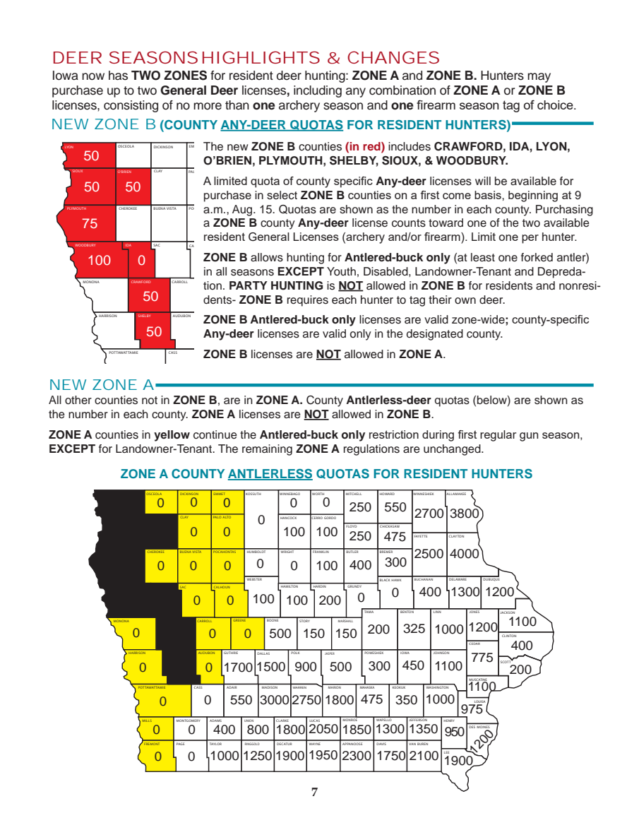
**THE ZONE A COUNTY ANTLERLESS QUOTAS MAP, booklet p.7 — 91 per-county antlerless licence quotas, AND THIS COMPILATION DOES NOT CARRY ONE OF THEM.** It is the map that tells a resident how many antlerless licences their county has. The numbers are not published because they cannot be paired with their counties safely, and that is a measurement rather than a shrug: pdfplumber merges adjacent counties' numbers into single tokens (`300027501800` is MADISON 3000 + WARREN 2750 + MARION 1800; `12501900` is RINGGOLD 1250 + DECATUR 1900); pypdf returns the numbers in an order unrelated to its own county-name order and merges them differently (`27500`, `12001300`, `38002700550`); 19 of the 99 numbers fall inside the bounding box of no drawn county polygon, so containment cannot pair them either; and DES MOINES county's `1200` is set rotated and returns as four one-character words. A published table of 91 numbers built on any of those readings would be plausible and wrong, which is the exact defect class this product exists to prevent. **WHAT IS CARRIED OFF THIS MAP IS THE EIGHTEEN YELLOW COUNTIES**, published above as a `limit` row, because that set is 1:1 with the drawn fills and is checkable three ways.
derived family: map
Who does have it
Not us. Iowa’s agency publishes the document this record was read from, and that document — not this page — is where the material above has to be chased:
https://www.iowadnr.gov/media/1700/download?inline=#page=6Where the description above names some other document, register, office or telephone number, that naming is the record’s own and is printed in full above. Nothing here has followed it up for you, and nothing here has re-typed it.
cross-references
**BOOKLET PAGE 5 PRINTS THE DEER LICENCE FEES AND IS NOT CITED.** Rendered and read: `LICENSE & FEES (beginning Dec. 15)` lists Paid Deer Licenses — General Deer $34.50, Antlerless-only First License $29.75, Antlerless-only Second & All Others $15.50 — and Landowner-Tenant Farm Unit Only — General Deer $2.00, Antlerless-only $2.00, Reduced Fee Antlerless-only $15.50 — plus the resident hunting licence and habitat fee that the p.6 table requires in words. A hunter cannot act on the seasons published here without those amounts, and this record does not carry them.
derived family: cross-reference
Who does have it
Not us. Iowa’s agency publishes the document this record was read from, and that document — not this page — is where the material above has to be chased:
https://www.iowadnr.gov/media/1700/download?inline=#page=6Where the description above names some other document, register, office or telephone number, that naming is the record’s own and is printed in full above. Nothing here has followed it up for you, and nothing here has re-typed it.
cross-references
The two cited pages point out of themselves and this compilation follows none of it. The p.6 footnotes and prose cite p.41 (bonus deer hunts, senior antlerless-only licences, and the DNR permit a Disabled Hunter licence requires), p.40 (resident deer licence options), p.42 (deadhead reporting; Landowner-Tenant deer licences), p.43 (deer-turkey tagging and harvest reporting) and www.iowadnr.gov/nonresidenthunting (the nonresident deer ZONE maps, which are a different zoning again from the ZONE A/ZONE B division published here). The p.5 contents page additionally lists Deer Management Zone Hunts (p.39), Chronic Wasting Disease (p.35), Legal Method of Take and Prohibited Devices (p.37) and Deer Hunting Information (p.36). All of it is real Iowa deer regulation and none of it is in this record.
derived family: cross-reference
Who does have it
Not us. Iowa’s agency publishes the document this record was read from, and that document — not this page — is where the material above has to be chased:
https://www.iowadnr.gov/media/1700/download?inline=#page=6Where the description above names some other document, register, office or telephone number, that naming is the record’s own and is printed in full above. Nothing here has followed it up for you, and nothing here has re-typed it.
4 further gap(s) the record says carry no regulation
declared by the record, which states these carry no regulation. They are published because the reason a thing was not read is part of the evidence.
graphic panel
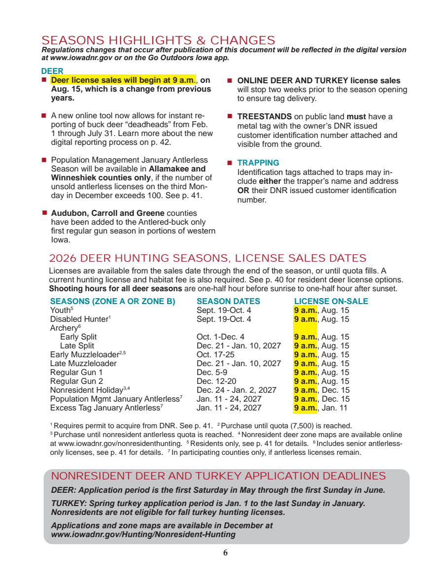
The only non-text object on p.6: one filled rounded rectangle, 494.9 x 101.4pt at x0=59.0 top=634.5, 25% black with no stroke — the grey background behind the "NONRESIDENT DEER AND TURKEY APPLICATION DEADLINES" block. 10.6% of the page by true union coverage; the page carries no images at all (0.0%), so there is no map, chart, photograph or logo band here. **It carries no regulation**: it is a fill behind live text, and every word inside it is in the text layer and is read — the nonresident DEER application period is emitted as a rule row from those very lines. Nothing on this page is encoded in colour or shape alone. The two yellow highlights (behind the first bullet and behind the "9 a.m." column) are rectangles the graphics measure does not count, and they mark text that is carried anyway: the 9 a.m. on-sale time is in `licence_on_sale` on all eleven season rows, and the fact that it is a change from previous years is stated in words in the first bullet.
derived family: photograph/graphic/advertisement
map
The "NEW ZONE B (COUNTY ANY-DEER QUOTAS FOR RESIDENT HUNTERS)" inset, booklet p.7. **It carries no regulation this record lacks**, and that is stated narrowly rather than generously: all eight ZONE B counties are enumerated in the prose beside it AND published here; all eight of its quota numbers are published as `limit` rows, each read from the single number inside its own red polygon and confirmed against a 6x render by eye (LYON 50, SIOUX 50, O'BRIEN 50, PLYMOUTH 75, WOODBURY 100, IDA 0, CRAWFORD 50, SHELBY 50). What the map alone carries is county geography — which physical territory each named county covers — which is true of any county map and is not a rule. **Its artboard is clipped**: it draws all 99 Iowa counties and shows about 24, and the ~75 invisible labels are ruled out one by one with the pixel measurement that established they are painted on no page.
derived family: map
other content
**THE TWO PAGE BOUNDARIES WERE RENDERED AND READ, WHICH IS THE ONLY REASON THIS RANGE CAN BE DEFENDED** — the previous citation was one page short and reported clean. p.5 (before the range) is `TABLE OF CONTENTS` and `LICENSE & FEES`; its contents list prints "Deer Hunting Changes, Seasons ....... 6" with the next entry "Hunting Seasons and Limits ....... 8", which is the publisher's own statement that the deer section is pp.6-7. p.8 (after the range) is `HUNTING SEASONS AND LIMITS` — pheasant, quail, partridge, grouse, rabbit, squirrel, groundhog, crow, pigeon, coyote — then 2027 spring turkey and the ruffed grouse zone, and carries no deer rule anywhere. The single vertical rule the continuation check sees on p.5 is the DISCLAIMER box, and every vertical rule it sees on p.7 is a county boundary segment on the ZONE A quota map — all ten of them between y=462.8 and y=644.0, inside that map, and none elsewhere on the page. Neither page continues the season table, and only rendering them could establish that: the signal that flagged p.7 as 'draws a table' was a map being drawn.
derived family: scope of the compilation
other species
This booklet covers turkey, migratory game birds, upland game and furbearers as well as deer, across 53 pages. Only the deer section is compiled.
derived family: scope of the compilation
Coverage
100.0% of MIXED, and the two halves are not the same thing. Booklet p.6 is one unit per pypdf text line, as before. Booklet p.7 is one unit per baseline-clustered visual row WITHIN ITS CLASS -- prose, ZONE A map, visible ZONE B map, clipped ZONE B map -- clustered separately because the clipped map's labels sit at the same height as the prose and behind it. A percentage over the whole is therefore a percentage of 66 text lines plus p.7's visual rows, and roughly half of p.7's units are county names off two maps whose per-county numbers are declared as a gap, not published
derived: this percentage is over the units named above, on the pages this record cites. It is not a percentage of the state's regulation. The gaps above are what a full percentage would have to count and cannot.
2 page(s) cited
6
7
2 page boundary/boundaries never inspected
p5 (beside cited p6) — **THE UNCITED NEIGHBOUR DRAWS A TABLE (1 vertical rules) AND THE CITED PAGE DOES NOT** — this is the category that produced Iowa. RENDER IT AND READ IT BEFORE BELIEVING ANYTHING ELSE ABOUT THIS STATE, so the continuation check cannot fire. NOT a clean result: it was never inspected.
p8 (beside cited p7) — the uncited neighbour draws none; the cited page does — the safest case, the neighbour is probably prose, but prose is how Utah lost nine pages, so the continuation check cannot fire. NOT a clean result: it was never inspected.
1 library repair(s)
line: -1; was: (arch (archery (below) (in ). -Ten 12001300 1250 12501900 1300 15. 1800 1900 1WR5IGH.T 2700 27500 3000 300027501800 3800 38002700550 550 A. ABLLAS ACK ADAIR ALLAMAKEE AM AN ANRIONOT APPANOOSE ARE ARiSsHAL AW AZDAOIR AntlPeOLKred-bJuASPEcR Antlered-buck Any-deer Aug. BEN BENTON BL BLACK BMAD BOONE BREMER BUC BUCHANAN BUQU BUREEN BUREN BUTLER BW CALLRAMAAKEEWFORD, CHICKASAW CLAYTON CLINTON CLcAYToONme CO CRAWFORD, DALLAS DAVIS DAVISAPPANOOSEWAYNE DECATUR DELAWARE DES DUBUQUE Disab Disabled, DlicenDECsATUeRs ELA EMMET EMMETTheK ENOTA EaR ElSiHcIEKensIeOWAs FAYET FAYETTE FLOYD FRANKLIN FREMONT GREENE GUTHRIE GUTHRIEHARRISON GUZTHROIE HARRISON HAWK HIGHLIGHTS HOWARD HUMBOLDT HUNTING HUSTONRY INAGGOL IOWA ISlOiNcenWsAReRENs JACKSON JACKSONTAMA JASPER JASPERDALLAS JOHNSON JONES JOvHNaSOlNid KAASAWny-deer KEOKUK KOSSUTH LEsRhowBnREM LIN LINN LL(in LNOT La Landowner-Tenant Limit LsOYDpecifiCcHIC MABOLuDTg. MADISON MAHASKA MARION MARIONWARREN MARSHALL MITCHELL MOI0NES MOINES MeONaT NE NED NOT O(INbESelow) OKiUnK ON ONE OcRToH OnSSUeTHw PAGE PARBOOTNEY PARTY PAcGEountyT.A POCAHONTAS POCAHOaNTA.Sm.H,U POLK POT POTTAWATTAMIE POWESHIEK PPaANOlOloSEweDdAVIS QuoFRAtNaKLINs Quotas RINGGOLD SCOTT SEASONS SEASONSHIGHLIGHTS SON STORY TAMA TAMIE TAYLOR TE TINGM TOAN The VAN WARREN WASHINGTON WAYNE WEBSTER WINNEBAGO WINNESHIEK WORTH WRIGHT YLZORONER Yout Youth, ZONE ZOVANN ZOWINNNEBAEGO ZOWNASHEING a.m., aMAHlAlSoKAwedKE allowed and and/or arWAeYN are areBUT areM as ch come count counties county county. countyF d, deeCLrIN.T deer. down each fire firearm). in inFRE incWlIuNNEdSHIeEKs includes is licenses new on onFAY only onlyPOW quotaDsES quotas rHeOWdARD) red) residWEeBSTnERt resident shown specific tioGREnENE. tion. untiMeITCsHE valid; now: DEER SEASONS HIGHLIGHTS & CHANGES Iowa now has TWO ZONES for resident deer hunting: ZONE A and ZONE B. Hunters may purchase up to two General Deer licenses, including any combination of ZONE A or ZONE B licenses, consisting of no more than one archery season and one firearm season tag of choice. NEW ZONE B (COUNTY ANY-DEER QUOTAS FOR RESIDENT HUNTERS) The new ZONE B counties (in red) includes CRAWFORD, IDA, LYON, LYON OSCEOLA DICKINSON 50 O’BRIEN, PLYMOUTH, SHELBY, SIOUX, & WOODBURY. SIOUX O'BRIEN CLAY PALO A limited quota of county specific Any-deer licenses will be available for 50 50 purchase in select ZONE B counties on a first come basis, beginning at 9 a.m., Aug. 15. Quotas are shown as the number in each county. Purchasing PLYMOUTH CHEROKEE BUENA VISTA 75 a ZONE B county Any-deer license counts toward one of the two available resident General Licenses (archery and/or firearm). Limit one per hunter. WOODBURY IDA SAC ZONE B allows hunting for Antlered-buck only (at least one forked antler) 100 0 in all seasons EXCEPT Youth, Disabled, Landowner-Tenant and Depreda- MONONA CRAWFORD CARROLL tion. PARTY HUNTING is NOT allowed in ZONE B for residents and nonresi- 50 dents- ZONE B requires each hunter to tag their own deer. HARRISON SHELBY AUDUBON ZONE B Antlered-buck only licenses are valid zone-wide; county-specific 50 Any-deer licenses are valid only in the designated county. ZONE B licenses are NOT allowed in ZONE A. NEW ZONE A All other counties not in ZONE B, are in ZONE A. County Antlerless-deer quotas (below) are shown as the number in each county. ZONE A licenses are NOT allowed in ZONE B. ZONE A counties in yellow continue the Antlered-buck only restriction during first regular gun season, EXCEPT for Landowner-Tenant. The remaining ZONE A regulations are unchanged. ZONE A COUNTY ANTLERLESS QUOTAS FOR RESIDENT HUNTERS LYON OSCEOLA DICKINSON EMMET KOSSUTH WINNEBAGO WORTH MITCHELL HOWARD WINNESHIEK ALLAMAKEE SIOUX 0 CLAY 0 PALO ALTO0 0 0 250 550 0 0 100 100 250 475 FAYETTE CLAYTON PLYMOUTH CHEROKEE BUENA VISTA POCAHONTAS HUMBOLDT WRIGHT FRANKLIN BUTLER BREMER 0 0 0 0 0 100 400 300 WOODBURY IDA SAC CALHOUN HAMILTON HARDIN GRUNDY 0 0 100 100 200 0 MONONA CRAWFORD CARROLL GREENE BOONE STORY MARSHALL 0 0 0 500 150 150 200 325 1000 1200 CLINTON HARRISON SHELBY AUDUBON GUTHRIE DALLAS POLK JASPER POWESHIEK IOWA JOHNSON 400 0 0 1700 1500 900 500 300 450 1100 MUSCATINE 200 POTTAWATTAMIE CASS ADAIR MADISON WARREN MARION MAHASKA KEOKUK WASHINGTON 0 0 550 300027501800 475 350 1000 MILLS MONTGOMERY ADAMS UNION CLARKE LUCAS MONROE WAPELLO JEFFERSON HENRY 0 0 400 800 1800 2050 1850 1300 1350 950 0 FREMONT PAGE TAYLOR RINGGOLD DECATUR WAYNE APPANOOSE DAVIS VAN BUREN 0 0 0 1000 12501900 1950 2300 1750 2100; basis: booklet page 7: `was` is the LIST of tokens the two libraries disagree about on this page, not a single string, and `now` is what this extraction consumed from it. 221 tokens diverge, and the mechanism is one thing: the NEW ZONE B inset's artboard draws all 99 counties, is CLIPPED to about 24, and its invisible labels sit at the same height as the prose column. pdfplumber's default reader interleaves them character by character and returns 'EMMETTheK', 'ZOWINNNEBAEGO', 'CALLRAMAAKEEWFORD,'; pypdf keeps the prose whole but merges adjacent map quota numbers into single tokens -- '27500', '12001300', '38002700550'. THIS ADAPTER READS NEITHER OF THOSE. It calls extract_words(extra_attrs=["size","fontname"]), which partitions the character stream by attribute first and returns the prose exactly as the rendered page prints it, and it publishes no ZONE A quota number at all -- the merging is itself the measured reason that map is declared as a gap
36 swept source line(s) in 3 reason group(s) — NOT declared gaps
These are not gaps.
ruled_out entries are source lines the extractor accounted for and did NOT publish, each with the reason it gave. They are not declared gaps: a declared gap is regulation the record says exists and it does not carry.
20 × — a label of the NEW ZONE B inset's artboard that is CLIPPED AWAY AND PAINTED ON NO PAGE. The inset draws all 99 Iowa counties and shows about 24; the rest extend east under the prose column. MEASURED ON THE 6x RENDER, not inferred: the 30% grey polygon at (411.1,134.6)-(448.8,177.5), labelled ALLAMAKEE, contains zero grey pixels, and scanlines through clean inter-line gaps of the prose at y=162pt and y=232pt find no non-white pixel beyond x=182.83pt. These words are why pdfplumber's DEFAULT extract_words returns 'CALLRAMAAKEEWFORD,' where the page prints 'ALLAMAKEE' and 'CRAWFORD,' -- they interleave with the prose in the character stream. Nothing is lost by not reading them: every county they name is drawn and labelled again, VISIBLY, on the ZONE A map lower on the same page, and those labels are ruled out separately with their own reason
EMMET KOSSUTH WINNEBAGO WORTH MITCHELL HOWARD WINNESHIEK ALLAMAKEE
ALTO HANCOCK CERRO GORDO
FLOYD CHICKASAW
FAYETTE CLAYTON
POCAHONTAS HUMBOLDT WRIGHT FRANKLIN BUTLER BREMER
WEBSTER BLACK HAWK BUCHANAN DELAWARE DUBUQUE
CALHOUN HAMILTON HARDIN GRUNDY
TAMA BENTON LINN JONES JACKSON
GREENE BOONE STORY MARSHALL
CLINTON
CEDAR
GUTHRIE DALLAS POLK JASPER POWESHIEK IOWA JOHNSON
SCOTT
MUSCATINE
ADAIR MADISON WARREN MARION MAHASKA KEOKUK WASHINGTON
LOUISA
MILLS MONTGOMERY ADAMS UNION CLARKE LUCAS MONROE WAPELLO JEFFERSON HENRY
DES MOINES
FREMONT PAGE TAYLOR RINGGOLD DECATUR WAYNE APPANOOSE DAVIS VAN BUREN
LEE
15 × — a county label or quota number inside the "ZONE A COUNTY ANTLERLESS QUOTAS FOR RESIDENT HUNTERS" map on booklet page 7. Both maps are declared as known gaps. What IS carried off them is stated there and published above: the eight ZONE B counties with their any-deer quotas, and the eighteen yellow ZONE A counties. The ZONE A per-county ANTLERLESS quota numbers are NOT carried and the declaration says why
O'BRIEN HANCOCK CERRO GORDO 2700 3800
0 FLOYD CHICKASAW
2500 4000
WEBSTER BLACK HAWK BUCHANAN DELAWARE DUBUQUE
0 400 1300 1200
TAMA BENTON LINN JONES JACKSON
1100
CEDAR
775 SCOTT
1100
LOUISA
975
DES MOINES
LEE 12
1900
1 × — a county label or quota number inside the "NEW ZONE B" map on booklet page 7. Both maps are declared as known gaps. What IS carried off them is stated there and published above: the eight ZONE B counties with their any-deer quotas, and the eighteen yellow ZONE A counties. The ZONE A per-county ANTLERLESS quota numbers are NOT carried and the declaration says why
POTTAWATTAMIE CASS
the same view across all records →